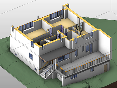
Services

Our company offers geospatial measurement of any kind of objects, data processing and documentation creation. For taking the measurements we use the latest high-quality technologies (laser scanners, aerial imaging systems, total stations, GNSS receivers, ...). For each project we select the best data capture method depending on the client's requirements, meaning the type of outputs, required accuracy and local conditions. 3D spatial data are then used by architects, for creating BIM models, for reconstructions, movement and change monitoring, volume calculation, precise agriculture, visualization and virtual reality, and for many more applications that require accurate and detailed 3D model.

Laser scanning

With high-technology laser scanners we are able to measure objects of any size and to create an accurate 3D model.

Photogrammetry

Images from camera placed on the ground or on a drone are used to generate 3D models and for mapping large areas.

Height inspections

We capture images and videos with a camera placed on a drone to inspect height constructions or simply to have nice shots.

Project cases

BIM model

3D measuring of a building and BIM modelling
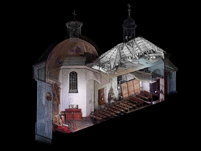
Historical building

Complete documentation of a chapel before reconstruction
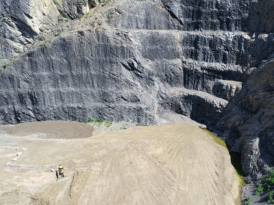
Quarries

Volume calculation of a material from aerial imaging data

Mapping

Mapping of an area before the beginning of earthwork
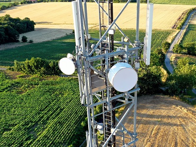
Height inspection

Detailed check of a height building
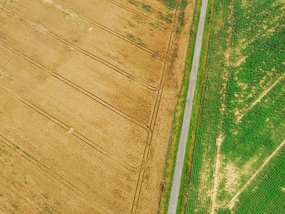
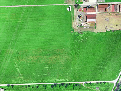
Agriculture

Aerial imaging of agricultural fields and vegetation health detection

About Us

We are a young dynamic company that offers new possibilities in surveying and geospatial data. We really enjoy doing what we are doing and that helps us being focused on detail and high-quality of our data. With our passion for geospatial data we like searching and discovering new possibilities. Thanks to many years of experience with projects all around the world our team has an excellent knowledge of the latest technologies and methods in geospatial measuring and 3D data processing. Our offices are in the Czech Republic (Central Bohemia region) and Switzerland (canton Valais), but for the needs of our clients we travel all around the world.

“Enthusiasm spells the difference between mediocrity and accomplishment.”

Norman Vincent Peale

Contact Us


Do you need to make 3D measurements of an object and create an accurate 3D model? Do you want a drone to do a flight above some area and capture high-quality images and videos? Do you think that the data from the UAV or laser scanner can be useful for your project, but you are not sure? Don't hesitate to contact us and let us know how can we help you with your project. We can discuss all the possibilities and find for you the best solution.
Let us know either by filling in the form or send us an email on info@scanbird.eu .

SCANBIRD Office Czech Republic

Žabovřesky 5, 25601 Benešov

Phone: +420 720 159 803       E-mail: info@scanbird.cz

.

SCANBIRD Office Switzerland

Route des Carroz 17, 1890 Saint-Maurice VS

Phone: +420 720 159 803       E-mail: info@scanbird.eu

.